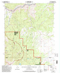
1994 Map of Cotopaxi
USGS Topo · Published 1998About this map
The Arkansas River corridor serves as the primary artery for human activity in this 1990s landscape, where the settlement of Cotopaxi sits at the junction of the river and Sand Gulch. Upstream to the west, Coaldale and Pleasanton are established along the valley floor, tucked between the river and the rising elevations of Gobblers Knob. The northern half of the map is defined by a series of rugged drainages like Mc Coy Gulch and Iron Dollar Gulch, where scattered mines indicate the area's mineral prospects.
Find a feature on this map
42 named features on this map. Tap any name to fly to it.
Don’t see what you’re looking for? This feature index may not catch every label — zoom into the map to look around manually.
Map Details
Editions of this 1994 Cotopaxi Map
This is the sole edition of this map. No revisions or reprints were ever made.
Other maps of this area

1950 · Valley View Hot Springs
USGS Topo · 1:24,000

1954 · Pueblo
USGS Topo · 1:250,000

1957 · Pueblo
USGS Topo · 1:250,000

1958 · Pueblo
USGS Topo · 1:250,000

1958 · Beckwith Mountain
USGS Topo · 1:24,000

1959 · Electric Peak
USGS Topo · 1:62,500

1959 · Howard
USGS Topo · 1:62,500

1959 · Cotopaxi
USGS Topo · 1:62,500

1962 · Pueblo
USGS Topo · 1:250,000

1966 · Pueblo
USGS Topo · 1:250,000