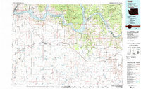
1983 Map of Coulee Dam
USGS Topo · Published 1983About this map
Franklin D Roosevelt Lake dominates the northern landscape, a massive reservoir created by the construction of the iconic dam that defines this region. The map captures the complex interaction between the engineered water system and the native lands of the Colville Indian Reservation and Spokane Indian Reservation. To the south, the terrain shifts into the high prairie and coulee country of Lincoln County, where the Burlington Northern railroad links agricultural hubs like Wilbur, Creston, and Davenport.
Find a feature on this map
107 named features on this map. Tap any name to fly to it.
Don’t see what you’re looking for? This feature index may not catch every label — zoom into the map to look around manually.
Map Details
Editions of this 1983 Coulee Dam Map
2 editions found
Other maps of this area

1927 · Chewelah
USGS Topo · 1:125,000

1930 · Chewelah
USGS Topo · 1:125,000

1944 · Wellpinit
USGS Topo · 1:62,500

1945 · Reardan
USGS Topo · 1:62,500

1948 · Grand Coulee Dam
USGS Topo · 1:62,500

1948 · Hunters
USGS Topo · 1:62,500

1948 · Wilbur
USGS Topo · 1:62,500

1948 · Wilmont Creek
USGS Topo · 1:62,500

1948 · Lincoln
USGS Topo · 1:62,500

1948 · Turtle Lake
USGS Topo · 1:62,500