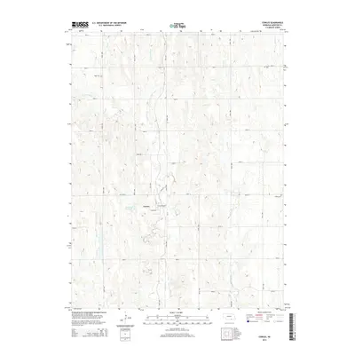
2014 Map of Cowles
USGS Topo · Published 2014About this map
Cowles sits at the heart of this Webster County landscape, defined by a grid of rural roads and the branching drainage of Elm Cr. The settlement is concentrated around Cowles Main St and Harlan St, serving as a central hub for the surrounding agricultural plains. Water management and local history are etched into the terrain, from the Gestring Reservoir west of town to several well-preserved burial grounds that dot the sections. Genealogists and local historians will find value in the placement of Batin Cem to the northwest, Salem Cem in the northeast, and Mulkey Cem on the eastern edge. The map captures the hydrological patterns of the region, including the confluence of W Fork Elm Cr and E Fork Elm Cr, as well as the path of Willow Cr through the eastern sections.
Find a feature on this map
32 named features on this map. Tap any name to fly to it.
Don’t see what you’re looking for? This feature index may not catch every label — zoom into the map to look around manually.
Map Details
Editions of this 2014 Cowles Map
This is the sole edition of this map. No revisions or reprints were ever made.
Other maps of this area

1897 · Red Cloud
USGS Topo · 1:125,000

1898 · Superior
USGS Topo · 1:125,000

1940 · Red Cloud
USGS Topo · 1:62,500

1942 · Red Cloud
USGS Topo · 1:62,500

1955 · Grand Island
USGS Topo · 1:250,000

1957 · Grand Island
USGS Topo · 1:250,000

1958 · Grand Island
USGS Topo · 1:250,000

1969 · Lawrence
USGS Topo · 1:24,000

1969 · Blue Hill
USGS Topo · 1:24,000
1969 · Bladen
USGS Topo · 1:24,000