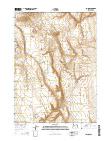
2014 Map of Cox Canyon
USGS Topo · Published 2014About this map
Cox Canyon and its complex system of high-desert water features define this portion of Harney County, Oregon. In a landscape where water management is critical for survival and land use, several reservoirs and localized sources are established across the township lines. Noteworthy landmarks include the Cox Butte Reservoir and Cox Grove Lake, while more distant outposts like the Bourbon Waterhole and End of the Trail Reservoir suggest the limits of accessibility in this arid environment. The presence of Little Juniper Rd provides a primary corridor through the terrain, connecting these vital water points. This survey reflects the persistence of cattle ranching and resource management in the high-desert basins of the early twenty-first century, showing the deliberate placement of wells and catchments such as the Empty Lake Well and Rehab Reservoir.
Find a feature on this map
14 named features on this map. Tap any name to fly to it.
Don’t see what you’re looking for? This feature index may not catch every label — zoom into the map to look around manually.
Map Details
Editions of this 2014 Cox Canyon Map
This is the sole edition of this map. No revisions or reprints were ever made.
Other maps of this area

1955 · Burns
USGS Topo · 1:250,000

1955 · Adel
USGS Topo · 1:250,000

1957 · Adel
USGS Topo · 1:250,000

1958 · Burns
USGS Topo · 1:250,000

1958 · Adel
USGS Topo · 1:250,000

1959 · Burns
USGS Topo · 1:250,000

1962 · Adel
USGS Topo · 1:250,000
1971 · Red Bank Lakes
USGS Topo · 1:24,000
1984 · Turpin Knoll
USGS Topo · 1:24,000
1984 · Dry Valley Rim
USGS Topo · 1:24,000