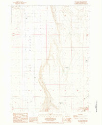
1984 Map of Dry Valley Rim
USGS Topo · Published 1984About this map
Dry Valley defines the landscape of this high desert region in southeast Oregon, as documented in this 1984 provisional survey. The terrain is marked by the prominent north-south escarpment of the Dry Valley Rim, a feature that dictates the movement of water and settlement in this arid environment. Human activity is sparse and centered on livestock and ranching, evidenced by the presence of Boyce Ranch and Mack Cabin. Water management is the critical lifeline for the area, shown through a series of isolated improvements including Dry Well, Fox Well, and the Dry Valley Rim Reservoir. The map illustrates how local geography and water scarcity influenced the placement of infrastructure like Dry Valley Rd, which follows the natural level floor of the valley west of the rim while drainages like Indian Creek and Rawhide Canyon cut through the higher ground to the east.
Find a feature on this map
16 named features on this map. Tap any name to fly to it.
Don’t see what you’re looking for? This feature index may not catch every label — zoom into the map to look around manually.
Map Details
Editions of this 1984 Dry Valley Rim Map
This is the sole edition of this map. No revisions or reprints were ever made.
Other maps of this area

1955 · Burns
USGS Topo · 1:250,000

1955 · Adel
USGS Topo · 1:250,000

1957 · Adel
USGS Topo · 1:250,000

1958 · Burns
USGS Topo · 1:250,000

1958 · Adel
USGS Topo · 1:250,000

1959 · Burns
USGS Topo · 1:250,000

1962 · Adel
USGS Topo · 1:250,000

1971 · Rock Camp Draw
USGS Topo · 1:24,000
1971 · Red Bank Lakes
USGS Topo · 1:24,000
1984 · Turpin Knoll
USGS Topo · 1:24,000