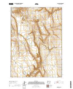
2020 Map of Cox Canyon
USGS Topo · Published 2020About this map
Cox Canyon and Clark Canyon carve through this high desert landscape of Harney County, illustrating a water-scarce environment managed through an extensive network of small reservoirs and catchment basins. Named features such as Cox Butte Reservoir and the uniquely titled End of the Trail Reservoir indicate the reliance on seasonal runoff to support livestock and land use in this arid region. The distribution of natural basins, including Buckaroo Lake, Big Lake, and Cox Grove Lake, alongside man-made improvements like the Bourbon Waterhole, reveals the infrastructure necessary for sustaining life and industry in the remote Oregon backcountry. Surveyed in the early 21st century, the map details the rugged topography and the essential relationship between the sparse natural hydrology and regional land management.
Find a feature on this map
18 named features on this map. Tap any name to fly to it.
Don’t see what you’re looking for? This feature index may not catch every label — zoom into the map to look around manually.
Map Details
Editions of this 2020 Cox Canyon Map
This is the sole edition of this map. No revisions or reprints were ever made.
Other maps of this area

1955 · Burns
USGS Topo · 1:250,000

1955 · Adel
USGS Topo · 1:250,000

1957 · Adel
USGS Topo · 1:250,000

1958 · Burns
USGS Topo · 1:250,000

1958 · Adel
USGS Topo · 1:250,000

1959 · Burns
USGS Topo · 1:250,000

1962 · Adel
USGS Topo · 1:250,000
1971 · Red Bank Lakes
USGS Topo · 1:24,000
1984 · Turpin Knoll
USGS Topo · 1:24,000
1984 · Dry Valley Rim
USGS Topo · 1:24,000