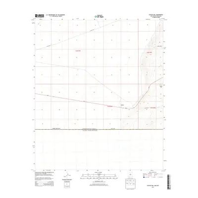
2013 Map of Coyote Hill
USGS Topo · Published 2013About this map
The international boundary between the United States and Mexico dominates the southern portion of this high-desert landscape in Luna County. The small settlement of Arena sits at the junction of several primitive routes and the primary thoroughfare, Highway 9, which cuts across the arid basin. To the east, the topography shifts abruptly as the land rises toward the namesake Coyote Hill and the adjacent Indian Basin, where steep elevation contours contrast with the flat plains to the west.
Find a feature on this map
11 named features on this map. Tap any name to fly to it.
Don’t see what you’re looking for? This feature index may not catch every label — zoom into the map to look around manually.
Map Details
Editions of this 2013 Coyote Hill Map
This is the sole edition of this map. No revisions or reprints were ever made.
Other maps of this area

1917 · Camel Mountain
USGS Topo · 1:62,500

1917 · Columbus
USGS Topo · 1:62,500

1918 · Columbus
USGS Topo · 1:62,500

1920 · Columbus
USGS Topo · 1:62,500

1953 · El Paso
USGS Topo · 1:250,000

1959 · El Paso
USGS Topo · 1:250,000

1964 · El Paso
USGS Topo · 1:250,000

1965 · El Paso
USGS Topo · 1:250,000
1965 · Camel Mountain
USGS Topo · 1:24,000
1965 · P O L Ranch
USGS Topo · 1:24,000