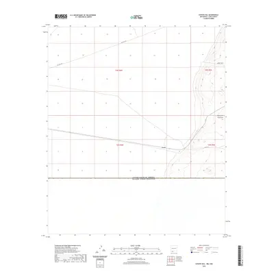
2020 Map of Coyote Hill
USGS Topo · Published 2020About this map
The international border between the United States of America and Estados Unidos Mexicanos anchors the southern edge of this Luna County landscape. The settlement of Arena sits at the junction of desert thoroughfares, marking a sparse but critical point of human presence in this arid borderland. To the northeast, the terrain rises toward the namesake Coyote Hill, while the low-lying Indian Basin defines the topography near the eastern margin. Transportation across this high-desert environment is primarily served by unpaved routes like Pol Ranch Rd and Anapra Rd, which traverse the vast township grids of T28S and T29S. The map illustrates a modern era of boundary management and rural land use along the New Mexico-Mexico line, where infrastructure is minimal and dictated by the natural drainage patterns and subtle elevation shifts of the Chihuahuan Desert.
Find a feature on this map
10 named features on this map. Tap any name to fly to it.
Don’t see what you’re looking for? This feature index may not catch every label — zoom into the map to look around manually.
Map Details
Editions of this 2020 Coyote Hill Map
This is the sole edition of this map. No revisions or reprints were ever made.
Other maps of this area

1917 · Camel Mountain
USGS Topo · 1:62,500

1917 · Columbus
USGS Topo · 1:62,500

1918 · Columbus
USGS Topo · 1:62,500

1920 · Columbus
USGS Topo · 1:62,500

1953 · El Paso
USGS Topo · 1:250,000

1959 · El Paso
USGS Topo · 1:250,000

1964 · El Paso
USGS Topo · 1:250,000

1965 · El Paso
USGS Topo · 1:250,000
1965 · Camel Mountain
USGS Topo · 1:24,000
1965 · P O L Ranch
USGS Topo · 1:24,000