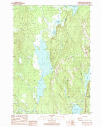
1990 Map of Crawford Lake
USGS Topo · Published 1990About this map
Crawford Lake and the East Machias River dominate this interior Washington County landscape, reflecting the glacial geography of eastern Maine. The small settlement of Crawford serves as a focal point among several distinct townships and plantations, including Plantation No 21 and the southern edge of Princeton. Significant topographic detail is captured along the numerous ridges that define the watershed, such as Seavey Ridge, Huntley Ridge, and Cedar Grove Ridge. The water system is particularly complex, featuring a string of interconnected bodies including Pocomoonshine Lake, Upper Mud Lake, and Lower Mud Lake. To the south and east, the map traces the shoreline of Love Lake and the smaller Barrows Lake, connected by winding waterways like Dead Brook and Barrows Stream. This late-century survey documents a region defined by its timber-country hydrology and sparse residential clusters.
Find a feature on this map
37 named features on this map. Tap any name to fly to it.
Don’t see what you’re looking for? This feature index may not catch every label — zoom into the map to look around manually.
Map Details
Editions of this 1990 Crawford Lake Map
This is the sole edition of this map. No revisions or reprints were ever made.
Other maps of this area

1929 · Calais
USGS Topo · 1:48,000

1932 · Calais
USGS Topo · 1:62,500

1941 · Wesley
USGS Topo · 1:62,500

1941 · Gardner Lake
USGS Topo · 1:62,500

1941 · Big Lake
USGS Topo · 1:62,500

1943 · Big Lake
USGS Topo · 1:62,500

1943 · Wesley
USGS Topo · 1:62,500

1943 · Gardner Lake
USGS Topo · 1:62,500

1952 · Big Lake
USGS Topo · 1:50,000

1957 · Fredericton
USGS Topo · 1:250,000