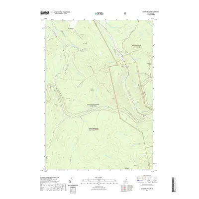
2021 Map of Crawford Notch
USGS Topo · Published 2021About this map
Crawford Notch serves as the central focal point of this high-altitude landscape, where the Saco River begins its descent through a narrow mountain pass. The topography is dominated by the White Mountain National Forest, featuring the massive silhouettes of the Rosebrook Mountains and the Presidential Range. A complex network of recreational paths, including the Appalachian National Scenic Trl and the Crawford Path Trl, crisscrosses the peaks, following old corridors such as the Zealand Trl and the Avalon Trl. The map illustrates a dramatic drainage system where Zealand Falls and Ripley Falls define the rugged watercourses of the Zealand River and its tributaries. Significant landmarks like Elephant Head and Silver Cascade emphasize the corridor's historic role as a gateway for travelers moving through the Notch, while numerous small bodies of water like Saco Lake and Ethan Pond are tucked into the high valleys.
Find a feature on this map
79 named features on this map. Tap any name to fly to it.
Don’t see what you’re looking for? This feature index may not catch every label — zoom into the map to look around manually.
Map Details
Editions of this 2021 Crawford Notch Map
This is the sole edition of this map. No revisions or reprints were ever made.
Other maps of this area

1893 · Mt. Washington
USGS Topo · 1:62,500

1895 · Crawford Notch
USGS Topo · 1:62,500

1896 · Mt. Washington
USGS Topo · 1:62,500

1896 · Crawford Notch
USGS Topo · 1:62,500

1900 · Whitefield
USGS Topo · 1:62,500

1929 · Franconia
USGS Topo · 1:62,500

1932 · Franconia
USGS Topo · 1:62,500

1935 · Whitefield
USGS Topo · 1:48,000

1935 · Mt. Washington
USGS Topo · 1:62,500
1938 · Mt. Washington
USGS Topo · 1:62,500