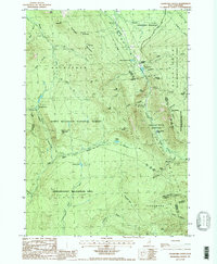
1987 Map of Crawford Notch
USGS Topo · Published 1987About this map
Crawford Notch State Park serves as the topographic centerpiece of this 1980s-era survey, highlighting the corridor along the Saco River and the historical mountain passage. The map documents significant local landmarks such as Crawford House and Willey House, alongside the Willey House Camps, which point to the area's enduring role in White Mountains tourism and heritage. The landscape is defined by its dramatic relief, featuring prominent summits like Mt Willard, Mt Field, and Mt Willey.
Find a feature on this map
64 named features on this map. Tap any name to fly to it.
Don’t see what you’re looking for? This feature index may not catch every label — zoom into the map to look around manually.
Map Details
Editions of this 1987 Crawford Notch Map
This is the sole edition of this map. No revisions or reprints were ever made.
Other maps of this area

1893 · Mt. Washington
USGS Topo · 1:62,500

1895 · Crawford Notch
USGS Topo · 1:62,500

1896 · Mt. Washington
USGS Topo · 1:62,500

1896 · Crawford Notch
USGS Topo · 1:62,500

1900 · Whitefield
USGS Topo · 1:62,500

1929 · Franconia
USGS Topo · 1:62,500

1932 · Franconia
USGS Topo · 1:62,500

1935 · Whitefield
USGS Topo · 1:48,000

1935 · Mt. Washington
USGS Topo · 1:62,500
1938 · Mt. Washington
USGS Topo · 1:62,500