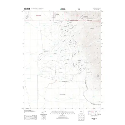
2013 Map of Crestone
USGS Topo · Published 2013About this map
The settlement of Crestone sits at the foot of the Sangre de Cristo Mountains, marking a transition from the high peaks of the Rio Grande National Forest to the unique desert landscapes of Great Sand Dunes National Park to the south. This 2013 survey illustrates the modern residential development of the Baca Grande, characterized by a dense network of streets like Camino Baca Grande and Badger Rd winding through the alluvial fans. In contrast to the developed residential sectors, the eastern edge of the map rises sharply into the wilderness, where numerous drainage systems such as Spanish Creek, Willow Creek, and Cottonwood Creek emerge from canyons. Genealogy and local history researchers can locate Teton Cem near the town center or trace the seasonal outpost at Alpine Camp along the banks of Deadman Creek at the southern boundary.
Find a feature on this map
84 named features on this map. Tap any name to fly to it.
Don’t see what you’re looking for? This feature index may not catch every label — zoom into the map to look around manually.
Map Details
Editions of this 2013 Crestone Map
This is the sole edition of this map. No revisions or reprints were ever made.
Other maps of this area

1954 · Trinidad
USGS Topo · 1:250,000

1954 · Pueblo
USGS Topo · 1:250,000

1955 · Trinidad
USGS Topo · 1:250,000

1957 · Pueblo
USGS Topo · 1:250,000

1958 · Trinidad
USGS Topo · 1:250,000

1958 · Pueblo
USGS Topo · 1:250,000

1959 · Trinidad
USGS Topo · 1:250,000

1959 · Electric Peak
USGS Topo · 1:62,500
1959 · Horn Peak
USGS Topo · 1:24,000

1962 · Pueblo
USGS Topo · 1:250,000