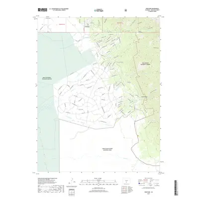
2019 Map of Crestone
USGS Topo · Published 2019About this map
Crestone serves as the primary hub in this high-altitude landscape, where the San Luis Valley meets the Sangre de Cristo Mountains. The map illustrates a complex network of residential access roads like Skyview Way and Panorama Way that spread across the alluvial fans between the mountains and the Baca National Wildlife Refuge. This late-2010s survey captures the intersection of conservation and community, showing the southern boundary of the Great Sand Dunes National Park as it reaches toward Deadman Creek. Genealogists and local researchers will find the Teton Cem north of town, while outdoor landmarks such as Happy Day Overlook and the trailhead for Spanish Creek Road provide clear reference points for those tracing the historical paths into the Rio Grande National Forest.
Find a feature on this map
96 named features on this map. Tap any name to fly to it.
Don’t see what you’re looking for? This feature index may not catch every label — zoom into the map to look around manually.
Map Details
Editions of this 2019 Crestone Map
This is the sole edition of this map. No revisions or reprints were ever made.
Other maps of this area

1954 · Trinidad
USGS Topo · 1:250,000

1954 · Pueblo
USGS Topo · 1:250,000

1955 · Trinidad
USGS Topo · 1:250,000

1957 · Pueblo
USGS Topo · 1:250,000

1958 · Trinidad
USGS Topo · 1:250,000

1958 · Pueblo
USGS Topo · 1:250,000

1959 · Trinidad
USGS Topo · 1:250,000

1959 · Electric Peak
USGS Topo · 1:62,500
1959 · Horn Peak
USGS Topo · 1:24,000

1962 · Pueblo
USGS Topo · 1:250,000