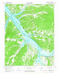
1965 Map of Cumberland City
USGS Topo · Published 1966About this map
The Cumberland River corridor in Stewart County was significantly altered following the impoundment of Lake Barkley. This survey captures the landscape as it transitioned into a federally protected habitat within the Cross Creek National Wildlife Refuge. The map details the interplay of the new shoreline with established upland features like Brigham Hill and Taylor Ridge, while the Louisville and Nashville railroad tracks follow the river's edge toward the settlement at Cumberland City.
Find a feature on this map
42 named features on this map. Tap any name to fly to it.
Don’t see what you’re looking for? This feature index may not catch every label — zoom into the map to look around manually.
Map Details
Editions of this 1965 Cumberland City Map
3 editions found
Other maps of this area

1931 · Erin
USGS Topo · 1:62,500

1936 · Tantrough Hollow
USGS Topo · 1:24,000

1936 · Stewart
USGS Topo · 1:24,000

1936 · Dover
USGS Topo · 1:24,000

1950 · Stewart
USGS Topo · 1:24,000

1950 · Dover
USGS Topo · 1:24,000

1951 · Indian Mound
USGS Topo · 1:24,000

1951 · Bumpus Mills
USGS Topo · 1:24,000

1951 · Woodlawn
USGS Topo · 1:24,000

1956 · Nashville
USGS Topo · 1:250,000