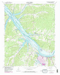
1965 Map of Cumberland City
USGS Topo · Published 1983About this map
Cumberland River and the newly formed Lake Barkley dominate this mid-century view of Stewart County, showing the landscape as it appeared shortly after the completion of the Barkley Dam downstream. The inundation of the river valley is a central feature, with the Cross Creek National Wildlife Refuge protecting the wetlands and inlets created by the rising waters. In the southeastern corner, Cumberland City sits at the bend of the river, served by the Seaboard railroad line. Local life and history are recorded through numerous small country churches like Dunbar Chapel and Scott Chapel, alongside rural settlements like Throckmorton. The geography is defined by deep hollows and ridges, such as Commissary Ridge and Brigham Hill, which overlook the complex network of creeks including Big Elk Creek and North Cross Creek that feed into the reservoir system.
Find a feature on this map
45 named features on this map. Tap any name to fly to it.
Don’t see what you’re looking for? This feature index may not catch every label — zoom into the map to look around manually.
Map Details
Editions of this 1965 Cumberland City Map
3 editions found
Other maps of this area

1931 · Erin
USGS Topo · 1:62,500

1936 · Tantrough Hollow
USGS Topo · 1:24,000

1936 · Stewart
USGS Topo · 1:24,000

1936 · Dover
USGS Topo · 1:24,000

1950 · Stewart
USGS Topo · 1:24,000

1950 · Dover
USGS Topo · 1:24,000

1951 · Indian Mound
USGS Topo · 1:24,000

1951 · Bumpus Mills
USGS Topo · 1:24,000

1951 · Woodlawn
USGS Topo · 1:24,000

1956 · Nashville
USGS Topo · 1:250,000