
1951 Map of Woodlawn
USGS Topo · Published 1953About this map
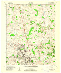
The Fort Campbell Military Reservation dominates the center of this landscape, its presence marked by an extensive network of fire breaks and numerous unidentified ruins scattered across the terrain. These structures suggest a previously inhabited rural landscape absorbed into the military training grounds. To the south, the settlements of Woodlawn and Oakwood remain as established communities along the local road network. The map reveals a transition between the organized military territory and the agrarian patterns of Montgomery County, where small social centers like Griffey Sch, Griffey Ch, and Elizabeth Ch served the local population. Waterways such as Fletchers Fork and Little West Fork carve through the topography, leading toward Cunningham Broadbent Lake in the southeast. This 1951 aerial study provides a detailed record of the physical impact of military expansion on the pre-existing Tennessee backcountry.
Find a feature on this map
31 named features on this map. Tap any name to fly to it.
Don’t see what you’re looking for? This feature index may not catch every label — zoom into the map to look around manually.
Map Details
Editions of this 1951 Woodlawn Map
This is the sole edition of this map. No revisions or reprints were ever made.
Other maps of this area

1931 · Erin
USGS Topo · 1:62,500

1944 · Clarksville
USGS Topo · 1:50,000

1951 · Roaring Spring
USGS Topo · 1:24,000

1951 · New Providence
USGS Topo · 1:24,000

1951 · Indian Mound
USGS Topo · 1:24,000

1951 · Herndon
USGS Topo · 1:24,000

1951 · Oak Grove
USGS Topo · 1:24,000

1956 · Nashville
USGS Topo · 1:250,000

1957 · New Providence
USGS Topo · 1:24,000
1957 · Oak Grove
USGS Topo · 1:24,000