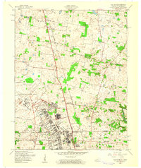
1957 Map of Oak Grove
USGS Topo · Published 1960About this map
Fort Campbell Military Reservation and the adjacent Campbell Air Force Base dominate this late 1950s landscape, revealing a high-density grid of barracks and training facilities along Kentucky Avenue and Indiana Avenue. The map straddles the border between Christian and Montgomery counties, capturing a time when military infrastructure transitioned into the rural communities of Fidelio and Saint Elmo. Small country congregations like Salem Ch and Lester Memorial Ch sit just beyond the military boundaries, while the Tennessee Central Railroad cuts a north-south path through the center of the sheet. Of particular interest to local historians is the site of Oak Grove (Thompsonville Sta) and the presence of an Airfield (Abandoned) within the reservation, reflecting the rapid changes in aviation and base layout during this era.
Find a feature on this map
36 named features on this map. Tap any name to fly to it.
Don’t see what you’re looking for? This feature index may not catch every label — zoom into the map to look around manually.
Map Details
Editions of this 1957 Oak Grove Map
This is the sole edition of this map. No revisions or reprints were ever made.
Other maps of this area

1944 · Clarksville
USGS Topo · 1:50,000

1950 · Pembroke
USGS Topo · 1:24,000

1951 · Pembroke
USGS Topo · 1:24,000

1951 · Church Hill
USGS Topo · 1:24,000

1951 · Hopkinsville
USGS Topo · 1:24,000

1951 · New Providence
USGS Topo · 1:24,000

1951 · Hammacksville
USGS Topo · 1:24,000

1951 · Clarksville
USGS Topo · 1:24,000

1951 · Herndon
USGS Topo · 1:24,000

1951 · Oak Grove
USGS Topo · 1:24,000