
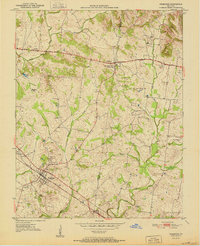
1951 Map of Pembroke
USGS Topo · Published 1951About this map
The town of Pembroke serves as a primary hub in this agricultural landscape at the southern edge of the state, where the Louisville and Nashville railroad tracks cut through the local topography. To the north, the Jefferson Davis State Park and its prominent Monument mark the village of Fairview, situated along the Jefferson Davis National Highway. This 1951 survey reveals a dense network of family history markers, including the Rosedale Cem, Gray Cem, and Shanklins Cem. The terrain is defined by the drainage of the South Fork Little River and the West Fork Red River, with rural life centered around community anchors like Barnetts Chapel and the County Home. The map illustrates a transition from established rail-oriented commerce to a growing reliance on the national highway system.
Find a feature on this map
25 named features on this map. Tap any name to fly to it.
Don’t see what you’re looking for? This feature index may not catch every label — zoom into the map to look around manually.
Map Details
Editions of this 1951 Pembroke Map
2 editions found
Other maps of this area

1944 · Clarksville
USGS Topo · 1:50,000

1950 · Guthrie
USGS Topo · 1:24,000

1950 · Pembroke
USGS Topo · 1:24,000

1951 · Elkton
USGS Topo · 1:24,000

1951 · Hopkinsville
USGS Topo · 1:24,000

1951 · Hammacksville
USGS Topo · 1:24,000

1951 · Oak Grove
USGS Topo · 1:24,000

1952 · Kelly
USGS Topo · 1:24,000

1952 · Allegre
USGS Topo · 1:24,000

1952 · Honey Grove
USGS Topo · 1:24,000