
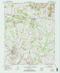
1950 Map of Pembroke
USGS Topo · Published 1968About this map
The Pembroke settlement serves as a primary hub for this agricultural region of Christian and Todd Counties at mid-century. Development is oriented along the Louisville and Nashville railroad and the Jefferson Davis National Highway, which connects the larger town to Fairview in the north. The landscape is dotted with small family and community burial grounds, including Rosedale Cem, Mason Cem, and Shanklins Cem, providing critical locations for genealogical research. Local spiritual life is centered around rural landmarks like Barnetts Chapel and Edgefield Church. The drainage pattern is defined by the West Fork Red River and Montgomery Creek, which wind through the farmland. A notable historical point is the Jefferson Davis State Park Monument, marking the heritage of this section of Kentucky.
Find a feature on this map
27 named features on this map. Tap any name to fly to it.
Don’t see what you’re looking for? This feature index may not catch every label — zoom into the map to look around manually.
Map Details
Editions of this 1950 Pembroke Map
2 editions found
Other maps of this area

1944 · Clarksville
USGS Topo · 1:50,000

1950 · Guthrie
USGS Topo · 1:24,000

1951 · Pembroke
USGS Topo · 1:24,000

1951 · Elkton
USGS Topo · 1:24,000

1951 · Hopkinsville
USGS Topo · 1:24,000

1951 · Hammacksville
USGS Topo · 1:24,000

1951 · Oak Grove
USGS Topo · 1:24,000

1952 · Kelly
USGS Topo · 1:24,000

1952 · Allegre
USGS Topo · 1:24,000

1952 · Honey Grove
USGS Topo · 1:24,000