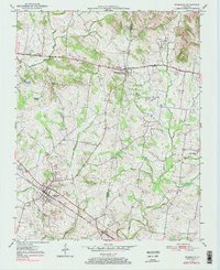
1950 Map of Pembroke
USGS Topo · Published 1984About this map
The Jefferson Davis State Park dominates the landscape of the Christian and Todd County line, marked by its prominent monument near the community of Fairview. The terrain is defined by the headwaters of the West Fork Red River and Montgomery Creek, where agricultural patterns are shaped by the winding paths of Little River and its South Fork. This mid-century survey captures the region just as traditional travel routes were transitioning, with the Jefferson Davis National Highway running east-west across the northern portion of the sheet.
Find a feature on this map
28 named features on this map. Tap any name to fly to it.
Don’t see what you’re looking for? This feature index may not catch every label — zoom into the map to look around manually.
Map Details
Editions of this 1950 Pembroke Map
2 editions found
Other maps of this area

1944 · Clarksville
USGS Topo · 1:50,000

1950 · Guthrie
USGS Topo · 1:24,000

1950 · Pembroke
USGS Topo · 1:24,000

1951 · Pembroke
USGS Topo · 1:24,000

1951 · Elkton
USGS Topo · 1:24,000

1951 · Hopkinsville
USGS Topo · 1:24,000

1951 · Hammacksville
USGS Topo · 1:24,000

1951 · Oak Grove
USGS Topo · 1:24,000

1952 · Kelly
USGS Topo · 1:24,000

1952 · Allegre
USGS Topo · 1:24,000