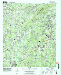
1999 Map of Cumming
USGS Topo · Published 2003About this map
Sawnee Mountain dominates the central horizon of this Forsyth County survey, creating a dramatic natural barrier between the expanding residential corridors and the higher gaps of Chamblee Gap and Tribble Gap. The city of Cumming serves as the focal point of the eastern sector, where the Forsyth Central High Sch and City Hall anchor a landscape transitioning from rural agricultural roots to suburban density. The map captures a moment of significant educational and civic growth, evidenced by the numerous schools ranging from Otwell Sch to the Vickery Creek Middle Sch in the southwest.
Find a feature on this map
73 named features on this map. Tap any name to fly to it.
Don’t see what you’re looking for? This feature index may not catch every label — zoom into the map to look around manually.
Map Details
Editions of this 1999 Cumming Map
This is the sole edition of this map. No revisions or reprints were ever made.
Other maps of this area

1890 · Suwanee
USGS Topo · 1:125,000

1894 · Suwanee
USGS Topo · 1:125,000

1926 · Tate
USGS Topo · 1:62,500

1928 · Tate
USGS Topo · 1:62,500

1955 · Rome
USGS Topo · 1:250,000

1956 · Duluth
USGS Topo · 1:24,000

1956 · Roswell
USGS Topo · 1:24,000

1956 · Birmingham
USGS Topo · 1:24,000

1958 · Rome
USGS Topo · 1:250,000

1961 · Rome
USGS Topo · 1:250,000