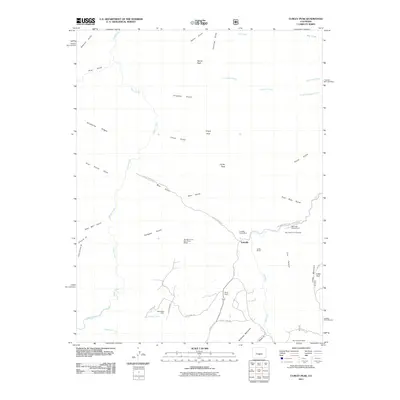
2011 Map of Curley Peak
USGS Topo · Published 2011About this map
Yorkville and several established ranching operations anchor this 2011 survey of the Fremont County high country. The landscape is defined by its mining heritage, with prospects like the Big Chief One Mine and the Big Mac Group One-Three Mines dotting the drainages. These sites, along with the Deer Ridge Claim, indicate a history of small-scale extraction and prospecting that survived alongside grazing lands such as the Griffin Ranch and Payne Ranch. The terrain is characterized by steep summits and deep cuts, including Tanner Peak and Curley Peak, while the canyon systems of Lion Canyon and Isinglass Gulch drain into the perennial Grape Creek. Recreation is evident at the Oak Creek Campground and Oak Creek Picnic Grounds, where the elevation rises toward Locke Mountain. The network of forest roads and county routes, including County Rd 143 and Oak Creek Grade Rd, provide the primary access to these isolated peaks and private holdings.
Find a feature on this map
45 named features on this map. Tap any name to fly to it.
Don’t see what you’re looking for? This feature index may not catch every label — zoom into the map to look around manually.
Map Details
Editions of this 2011 Curley Peak Map
This is the sole edition of this map. No revisions or reprints were ever made.
Other maps of this area

1889 · Canon City
USGS Topo · 1:125,000

1892 · Canon City
USGS Topo · 1:125,000

1954 · Mount Tyndall
USGS Topo · 1:24,000

1954 · Pueblo
USGS Topo · 1:250,000

1955 · Westcliffe
USGS Topo · 1:24,000

1957 · Pueblo
USGS Topo · 1:250,000

1958 · Pueblo
USGS Topo · 1:250,000
1959 · Canon City
USGS Topo · 1:24,000

1959 · Rockvale
USGS Topo · 1:24,000

1959 · Royal Gorge
USGS Topo · 1:62,500