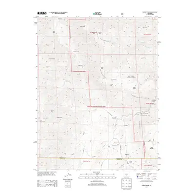
2013 Map of Curley Peak
USGS Topo · Published 2013About this map
Yorkville and Galena anchor the lower elevations of this 2013 survey, where the drainages of Oak Creek and Grape Creek cut through the eastern edge of the San Isabel National Forest. The map captures a transition from private ranchlands like Griffin Ranch and Payne Ranch into a high-altitude backcountry defined by peaks and ridges. A complex network of trails, including the Tanner / East Bear Gulch Trail 1333 and Stultz Trail 1334, crisscrosses the terrain, providing access to landmarks such as Curley Peak and Tanner Peak. The presence of residential developments near the Fremont-Custer county line, evidenced by street names like Chocktaw Drive and Sioux Circle, contrasts with the recreation-focused areas of Oak Creek Campground and the high basin of Locke Park.
Find a feature on this map
61 named features on this map. Tap any name to fly to it.
Don’t see what you’re looking for? This feature index may not catch every label — zoom into the map to look around manually.
Map Details
Editions of this 2013 Curley Peak Map
This is the sole edition of this map. No revisions or reprints were ever made.
Other maps of this area

1889 · Canon City
USGS Topo · 1:125,000

1892 · Canon City
USGS Topo · 1:125,000

1954 · Mount Tyndall
USGS Topo · 1:24,000

1954 · Pueblo
USGS Topo · 1:250,000

1955 · Westcliffe
USGS Topo · 1:24,000

1957 · Pueblo
USGS Topo · 1:250,000

1958 · Pueblo
USGS Topo · 1:250,000
1959 · Canon City
USGS Topo · 1:24,000

1959 · Rockvale
USGS Topo · 1:24,000

1959 · Royal Gorge
USGS Topo · 1:62,500