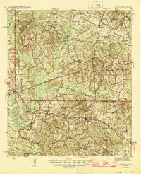
1945 Map of Cushing
USGS Topo · Published 1945About this map
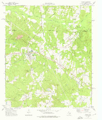
Cushing and the rural borderlands of Nacogdoches Co and Rusk Co appear here during a period of established agrarian life and rail-dependent commerce. The Southern Pacific railroad serves as the primary industrial artery, connecting the settlements of Sacul and Reklaw to the broader Texas market. The landscape is defined by the significant topographic rise of the Elk Mountains and Denman Mtn, while the river bottoms of the Angelina River and Mud Creek provide the drainage for numerous small-scale farming communities. Social life in the 1940s is anchored by a dense network of country schools and churches, such as Glenfawn Sch and Beech Grove Ch, reflecting a time before the widespread consolidation of rural districts. Local history enthusiasts can trace the old road alignments of 84 and 204 as they navigate the ridges and creek valleys of this East Texas timber and farm country.
Find a feature on this map
60 named features on this map. Tap any name to fly to it.
Don’t see what you’re looking for? This feature index may not catch every label — zoom into the map to look around manually.
Map Details
Editions of this 1945 Cushing Map
This is the sole edition of this map. No revisions or reprints were ever made.
Historical Maps of Cushing Through Time
8 maps found