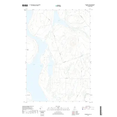
2018 Map of Cuxabexis Lake
USGS Topo · Published 2018About this map
Cuxabexis Lake and the northeastern reaches of Chesuncook Lake dominate this Piscataquis County landscape, where the Maine woods are defined by a network of remote logging roads and waterways. The map illustrates a transitional hydrologic zone where Cuxabexis Stream flows between bodies of water, and smaller catchments like Duck Pond and Logan Bog break up the forested interior. Transportation here is strictly utilitarian, marked by gravel paths such as Duck Pond Rd and Red Brook Rd that navigate the varied terrain between Gero Island and the mainland. In the southern portion of the sheet, drainage is defined by Red Brook and the W Br Red Brook, showing the natural flow toward the larger lake system. This topographic study reflects the modern managed wilderness, where the infrastructure of the timber industry meets the enduring geography of the North Maine Woods.
Find a feature on this map
20 named features on this map. Tap any name to fly to it.
Don’t see what you’re looking for? This feature index may not catch every label — zoom into the map to look around manually.
Map Details
Editions of this 2018 Cuxabexis Lake Map
This is the sole edition of this map. No revisions or reprints were ever made.
Other maps of this area

1953 · Telos Lake
USGS Topo · 1:62,500

1954 · Chesuncook
USGS Topo · 1:62,500

1954 · Grant Farm
USGS Topo · 1:62,500

1954 · Harrington Lake
USGS Topo · 1:62,500

1954 · Presque Isle
USGS Topo · 1:250,000

1954 · Millinocket
USGS Topo · 1:250,000

1957 · Telos Lake
USGS Topo · 1:62,500

1958 · Presque Isle
USGS Topo · 1:250,000

1958 · Millinocket
USGS Topo · 1:250,000

1958 · Chesuncook
USGS Topo · 1:62,500