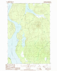
1988 Map of Cuxabexis Lake
USGS Topo · Published 1988About this map
Cuxabexis Lake and the northern reaches of Chesuncook Lake dominate this landscape in the Maine north woods. The terrain is defined by a dense network of waterways, including Umbazooksus Stream and the West Branch Brook, which flow through a region largely designated as State Reserve Land. This 1988 provisional edition captures the wilderness character of Piscataquis County, where timber and land management are the primary human signatures. Surveying of the area follows the township and range system, marking sections such as T 5 R 12 Wels. Small industrial details appear in the form of a Gravel Pit, while natural landmarks like Gero Island and Togue Ledge provide orientation within the expansive water system. The presence of Logan Bog and numerous smaller ponds like Duck Pond illustrates the intricate drainage patterns of this undeveloped interior.
Find a feature on this map
26 named features on this map. Tap any name to fly to it.
Don’t see what you’re looking for? This feature index may not catch every label — zoom into the map to look around manually.
Map Details
Editions of this 1988 Cuxabexis Lake Map
This is the sole edition of this map. No revisions or reprints were ever made.
Other maps of this area

1953 · Telos Lake
USGS Topo · 1:62,500

1954 · Chesuncook
USGS Topo · 1:62,500

1954 · Grant Farm
USGS Topo · 1:62,500

1954 · Harrington Lake
USGS Topo · 1:62,500

1954 · Presque Isle
USGS Topo · 1:250,000

1954 · Millinocket
USGS Topo · 1:250,000

1957 · Telos Lake
USGS Topo · 1:62,500

1958 · Presque Isle
USGS Topo · 1:250,000

1958 · Millinocket
USGS Topo · 1:250,000

1958 · Chesuncook
USGS Topo · 1:62,500