1955 Map of Dahlgren
USGS Topo · Published 1956About this map
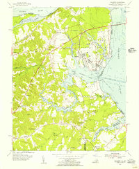
The U S Naval Proving Ground dominates the eastern landscape along the Potomac River, featuring an extensive military infrastructure including the Burgess Airfield and the Potomac River Bridge (Toll) connecting to Maryland. Away from the shoreline, the interior of King George County is defined by a dense network of small communities and rural landmarks. Settlements such as Berthaville, Owens, and Tetotum are linked by the Blue and Star Memorial Highway, while the landscape is punctuated by local spiritual centers like Little Ark Ch and Union Bethel Ch.
Find a feature on this map
50 named features on this map. Tap any name to fly to it.
Don’t see what you’re looking for? This feature index may not catch every label — zoom into the map to look around manually.
Map Details
Editions of this 1955 Dahlgren Map
This is the sole edition of this map. No revisions or reprints were ever made.
Other maps of this area

1889 · Fredericksburg
USGS Topo · 1:125,000

1892 · Fredericksburg
USGS Topo · 1:125,000

1892 · Montross
USGS Topo · 1:62,500

1894 · Wicomico
USGS Topo · 1:62,500

1894 · Fredericksburg
USGS Topo · 1:125,000

1895 · Wicomico
USGS Topo · 1:62,500

1895 · Nomini
USGS Topo · 1:125,000

1895 · Montross
USGS Topo · 1:62,500

1898 · Nomini
USGS Topo · 1:125,000

1902 · Wicomico
USGS Topo · 1:62,500