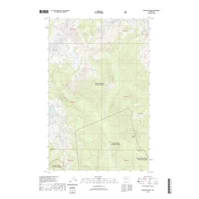
2020 Map of Damnation Peak
USGS Topo · Published 2020About this map
North Cascades National Park dominates this high-altitude landscape in the North Cascades, where the terrain is defined by extreme relief and an intricate network of alpine drainages. The map center is dominated by the steep ridges surrounding Berdeen Lake, with the waters of Bacon Cr and its E Fork carving deep valleys through the wilderness. To the east, the namesake Damnation Peak and Damnation Cr sit adjacent to Triumph Lake and the towering Mt Despair, illustrating the formidable character of this protected region. The map also delineates the convergence of three major public land units: the National Park, Mount Baker National Forest, and the Ross Lake National Recreation Area. These boundaries, along with the Whatcom Co Skagit Co line, underscore the area's role as a critical wilderness interface. High peaks like Hagan Mtn and Oakes Peak serve as primary landmarks in this roadless expanse.
Find a feature on this map
33 named features on this map. Tap any name to fly to it.
Don’t see what you’re looking for? This feature index may not catch every label — zoom into the map to look around manually.
Map Details
Editions of this 2020 Damnation Peak Map
This is the sole edition of this map. No revisions or reprints were ever made.
Other maps of this area

1909 · Mt Baker
USGS Topo · 1:192,000

1915 · Mt. Baker
USGS Topo · 1:250,000

1952 · Lake Shannon
USGS Topo · 1:62,500

1953 · Mt Shuksan
USGS Topo · 1:62,500

1953 · Marblemount
USGS Topo · 1:62,500

1953 · Mt Challenger
USGS Topo · 1:62,500

1955 · Concrete
USGS Topo · 1:250,000

1958 · Concrete
USGS Topo · 1:250,000

1962 · Concrete
USGS Topo · 1:250,000

1979 · Mt. Baker
USGS Topo · 1:100,000