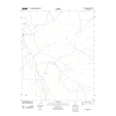
2011 Map of Dancing Rocks
USGS Topo · Published 2011About this map
Rock Point serves as the primary hub of this high-desert landscape, where the local infrastructure is defined by a network of tribal routes. The settlement, situated near the northwestern corner, is supported by the Rock Point Airport and sits just north of the expansive Carson Mesa. This 2011 survey reveals a geography shaped by intermittent watercourses, most notably the Lukachukai Wash which meanders through the western half of the quadrangle, and Hasbidito Creek in the southeast. Named geological formations like Hat Rock and the namesake Dancing Rocks provide distinct landmarks across the open terrain. The road system, including Indian Rte 35, Indian Rte 8070, and the curiously named Sanitary Rd, illustrates the connectivity between these remote geological features and the community at Rock Point.
Find a feature on this map
15 named features on this map. Tap any name to fly to it.
Don’t see what you’re looking for? This feature index may not catch every label — zoom into the map to look around manually.
Map Details
Editions of this 2011 Dancing Rocks Map
This is the sole edition of this map. No revisions or reprints were ever made.
Other maps of this area

1892 · Canyon De Chelly
USGS Topo · 1:250,000

1953 · Los Gigantes NW
USGS Topo · 1:24,000

1953 · Dinne Mesa SW
USGS Topo · 1:24,000

1953 · Los Gigantes SW
USGS Topo · 1:24,000

1953 · Toh-Atin Mesa
USGS Topo · 1:62,500

1953 · Los Gigantes Buttes
USGS Topo · 1:62,500

1954 · Shiprock
USGS Topo · 1:250,000

1958 · Shiprock
USGS Topo · 1:250,000

1959 · Shiprock
USGS Topo · 1:250,000
1968 · Hogansaani Spring
USGS Topo · 1:24,000