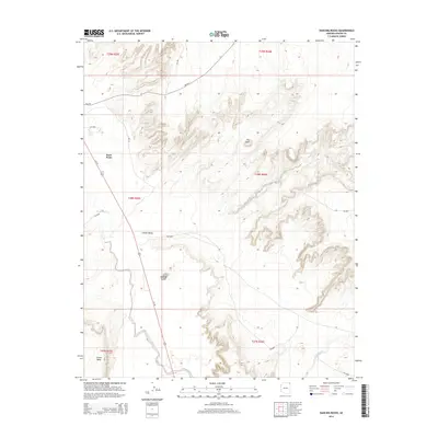
2014 Map of Dancing Rocks
USGS Topo · Published 2014About this map
Chinle Valley dominates the western half of this 2014 survey, where the wide corridor of Chinle Wash winds past the settlement at Rock Point. The landscape is defined by its dramatic topographic relief, rising from the wash floor up to the high, broken edges of Carson Mesa in the southwest and a series of unnamed ridges to the east. Several distinctive geological landmarks are mapped in detail, including the isolated prominence of Hat Rock and the eponymous Dancing Rocks.
Find a feature on this map
23 named features on this map. Tap any name to fly to it.
Don’t see what you’re looking for? This feature index may not catch every label — zoom into the map to look around manually.
Map Details
Editions of this 2014 Dancing Rocks Map
This is the sole edition of this map. No revisions or reprints were ever made.
Other maps of this area

1892 · Canyon De Chelly
USGS Topo · 1:250,000

1953 · Los Gigantes NW
USGS Topo · 1:24,000

1953 · Dinne Mesa SW
USGS Topo · 1:24,000

1953 · Los Gigantes SW
USGS Topo · 1:24,000

1953 · Toh-Atin Mesa
USGS Topo · 1:62,500

1953 · Los Gigantes Buttes
USGS Topo · 1:62,500

1954 · Shiprock
USGS Topo · 1:250,000

1958 · Shiprock
USGS Topo · 1:250,000

1959 · Shiprock
USGS Topo · 1:250,000
1968 · Hogansaani Spring
USGS Topo · 1:24,000