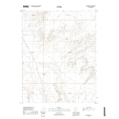
2018 Map of Dancing Rocks
USGS Topo · Published 2018About this map
Chinle Valley is the central topographical focus of this Arizona landscape, characterized by the wide drainage of Chinle Wash. The area is dominated by striking geological formations, most notably the eponymous Dancing Rocks and the prominent Hat Rock. The terrain transitions from the broad valley floors into elevated features such as Carson Mesa to the southwest, with drainage provided by the seasonal courses of Lukachukai Creek and Hasbidito Cr. A network of tribal routes, including Indian Rte 8009 and Indian Rte 35, provide the primary access through this remote portion of Apache County. The map details the specific township and range boundaries that define the local land administration within the Navajo Nation.
Find a feature on this map
20 named features on this map. Tap any name to fly to it.
Don’t see what you’re looking for? This feature index may not catch every label — zoom into the map to look around manually.
Map Details
Editions of this 2018 Dancing Rocks Map
This is the sole edition of this map. No revisions or reprints were ever made.
Other maps of this area

1892 · Canyon De Chelly
USGS Topo · 1:250,000

1953 · Los Gigantes NW
USGS Topo · 1:24,000

1953 · Dinne Mesa SW
USGS Topo · 1:24,000

1953 · Los Gigantes SW
USGS Topo · 1:24,000

1953 · Toh-Atin Mesa
USGS Topo · 1:62,500

1953 · Los Gigantes Buttes
USGS Topo · 1:62,500

1954 · Shiprock
USGS Topo · 1:250,000

1958 · Shiprock
USGS Topo · 1:250,000

1959 · Shiprock
USGS Topo · 1:250,000
1968 · Hogansaani Spring
USGS Topo · 1:24,000