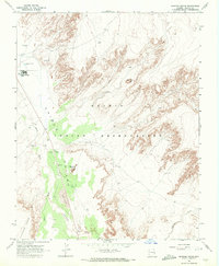
1968 Map of Dancing Rocks
USGS Topo · Published 1972About this map
Chinle Valley dominates this high-desert landscape within the Navajo Indian Reservation, where the intricate erosion of Carson Mesa meets the vast Sand Dunes. The map documents a sparse but vital infrastructure centered near Rock Point Boarding Sch, featuring a Rock Point Airstrip, Water Tanks, and Sewage Disposal Ponds. The terrain is punctuated by distinctive geological landmarks such as Hat Rock and the namesake Dancing Rocks.
Find a feature on this map
21 named features on this map. Tap any name to fly to it.
Don’t see what you’re looking for? This feature index may not catch every label — zoom into the map to look around manually.
Map Details
Editions of this 1968 Dancing Rocks Map
This is the sole edition of this map. No revisions or reprints were ever made.
Other maps of this area

1892 · Canyon De Chelly
USGS Topo · 1:250,000

1953 · Los Gigantes NW
USGS Topo · 1:24,000

1953 · Dinne Mesa SW
USGS Topo · 1:24,000

1953 · Los Gigantes SW
USGS Topo · 1:24,000

1953 · Toh-Atin Mesa
USGS Topo · 1:62,500

1953 · Los Gigantes Buttes
USGS Topo · 1:62,500

1954 · Shiprock
USGS Topo · 1:250,000

1958 · Shiprock
USGS Topo · 1:250,000

1959 · Shiprock
USGS Topo · 1:250,000
1968 · Hogansaani Spring
USGS Topo · 1:24,000