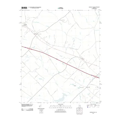
2011 Map of Danville East
USGS Topo · Published 2011About this map
Danville and Allentown serve as the primary hubs on this map, positioned along a major transit corridor that defines the movement of people and commerce through the central Georgia landscape. The map illustrates a network of rural routes named for local families and landmarks, such as Mobley White Rd and Harry Green Rd, which branch out toward smaller communities like Montrose and Laurens Hill. This pattern of settlement is closely tied to the hydrologic system, with numerous creeks including Turkey Creek, Devils Branch, and Rocky Creek carving through the terrain. Civil engineering features like the E Cuyler Adams Bridge and the Harrison Lake Dam at Harrison Lake demonstrate the historical management of these waterways. The presence of the Danville Post Office and Allentown Post Office highlights the civic centers that have sustained this region's local identity and connectivity over the decades.
Find a feature on this map
46 named features on this map. Tap any name to fly to it.
Don’t see what you’re looking for? This feature index may not catch every label — zoom into the map to look around manually.
Map Details
Editions of this 2011 Danville East Map
This is the sole edition of this map. No revisions or reprints were ever made.
Other maps of this area

1956 · Cochran
USGS Topo · 1:62,500

1956 · Jeffersonville
USGS Topo · 1:62,500

1957 · Macon
USGS Topo · 1:250,000

1958 · Macon
USGS Topo · 1:250,000

1964 · Macon
USGS Topo · 1:250,000

1974 · Chester
USGS Topo · 1:24,000

1974 · Danville East
USGS Topo · 1:24,000

1974 · Dudley
USGS Topo · 1:24,000
1974 · Nicklesville
USGS Topo · 1:24,000
1974 · Stuckey Boone Lake
USGS Topo · 1:24,000