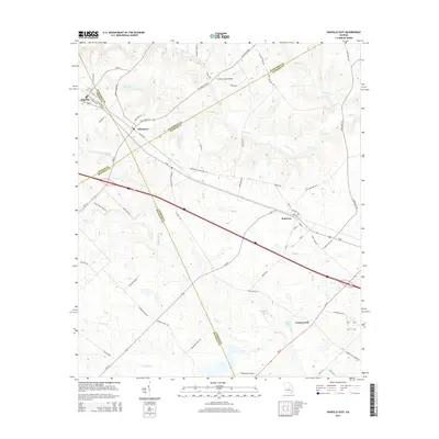
2014 Map of Danville East
USGS Topo · Published 2014About this map
Danville and Allentown sit at the northern edge of this Middle Georgia landscape, where the convergence of four county lines — Twiggs, Wilkinson, Bleckley, and Laurens — defines the local geography. The area is characterized by a complex network of tributaries including Turkey Cr, Devils Br, and Little Rocky Cr that feed into larger basins. To the southeast, the small community of Montrose serves as a local hub along Us-80, while the settlement of Laurens Hill marks the lower reaches of the quadrangle. Transport and infrastructure are represented by the Whitehall Airport and a grid of rural routes like Balls Ferry RD and Laurens Hill Church RD. The terrain is dotted with small bodies of water such as Harrison Lake and Morris Lake, illustrating a landscape shaped by agricultural drainage and local creek systems.
Find a feature on this map
67 named features on this map. Tap any name to fly to it.
Don’t see what you’re looking for? This feature index may not catch every label — zoom into the map to look around manually.
Map Details
Editions of this 2014 Danville East Map
This is the sole edition of this map. No revisions or reprints were ever made.
Other maps of this area

1956 · Cochran
USGS Topo · 1:62,500

1956 · Jeffersonville
USGS Topo · 1:62,500

1957 · Macon
USGS Topo · 1:250,000

1958 · Macon
USGS Topo · 1:250,000

1964 · Macon
USGS Topo · 1:250,000

1974 · Chester
USGS Topo · 1:24,000

1974 · Danville East
USGS Topo · 1:24,000

1974 · Dudley
USGS Topo · 1:24,000
1974 · Nicklesville
USGS Topo · 1:24,000
1974 · Stuckey Boone Lake
USGS Topo · 1:24,000