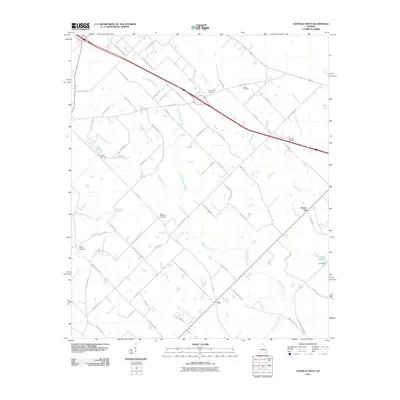
2011 Map of Danville West
USGS Topo · Published 2011About this map
Cary sits at a geographic crossroads in this central Georgia landscape, where a network of rural routes like Dillard-Cary Rd and Cary Rd converge. The terrain is defined by a dense web of waterways, most notably the meandering Gum Swamp Creek and its many tributaries including Gum Swamp Branch and Harvey Branch. These drainages create a complex pattern of wetlands and small impoundments such as Cason Lake and Land Lake, each held by namesake structures like the Cason Lake Dam. Local history is anchored by numerous family and community burial grounds, including the Mount Zion Cemetery, Fowler Cemetery, and the Lizzy Harold Cemetery. Aviation interest is represented by the Danville Airpark near the eastern margin, while topographical features like Brown Hill rise above the surrounding creek bottoms.
Find a feature on this map
75 named features on this map. Tap any name to fly to it.
Don’t see what you’re looking for? This feature index may not catch every label — zoom into the map to look around manually.
Map Details
Editions of this 2011 Danville West Map
This is the sole edition of this map. No revisions or reprints were ever made.
Other maps of this area

1956 · Cochran
USGS Topo · 1:62,500

1956 · Jeffersonville
USGS Topo · 1:62,500

1957 · Macon
USGS Topo · 1:250,000

1958 · Macon
USGS Topo · 1:250,000

1964 · Macon
USGS Topo · 1:250,000

1973 · Tarversville
USGS Topo · 1:24,000
1973 · Marion
USGS Topo · 1:24,000

1974 · Chester
USGS Topo · 1:24,000

1974 · Danville East
USGS Topo · 1:24,000
1974 · Stuckey Boone Lake
USGS Topo · 1:24,000