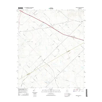
2014 Map of Danville West
USGS Topo · Published 2014About this map
Danville occupies the northeastern corner of this landscape, positioned along the historic corridor of Us-80 and the railroad. The terrain is defined by a dense network of tributaries including Gum Swamp Cr, Rocky Cr, and Reedy Cr, which carve through the land between the small settlements of the region. To the south, Cary sits at the junction of Ga-112, serving as a focal point for the surrounding rural area.
Find a feature on this map
85 named features on this map. Tap any name to fly to it.
Don’t see what you’re looking for? This feature index may not catch every label — zoom into the map to look around manually.
Map Details
Editions of this 2014 Danville West Map
This is the sole edition of this map. No revisions or reprints were ever made.
Other maps of this area

1956 · Cochran
USGS Topo · 1:62,500

1956 · Jeffersonville
USGS Topo · 1:62,500

1957 · Macon
USGS Topo · 1:250,000

1958 · Macon
USGS Topo · 1:250,000

1964 · Macon
USGS Topo · 1:250,000

1973 · Tarversville
USGS Topo · 1:24,000
1973 · Marion
USGS Topo · 1:24,000

1974 · Chester
USGS Topo · 1:24,000

1974 · Danville East
USGS Topo · 1:24,000
1974 · Stuckey Boone Lake
USGS Topo · 1:24,000