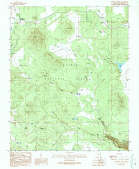
1989 Map of Davenport Hill
USGS Topo · Published 1990About this map
Kaibab National Forest dominates this northern Arizona landscape, where the high-country plateau is deeply cut by drainage systems like Big Canyon and Isham Canyon. Settled outposts such as Pouquette Homestead, Rancho Viejo, and the Moose Ranch are scattered across the terrain, reflecting the area's history of ranching and early mountain habitation. Water management is a central theme of the map, evidenced by a dense network of catchment features including the Dogtown Reservoir, Scholz Lake, and numerous stock tanks like the Santa Fe Tank and Reeder Tank.
Find a feature on this map
59 named features on this map. Tap any name to fly to it.
Don’t see what you’re looking for? This feature index may not catch every label — zoom into the map to look around manually.
Map Details
Editions of this 1989 Davenport Hill Map
This is the sole edition of this map. No revisions or reprints were ever made.
Other maps of this area

1886 · San Francisco Mtns
USGS Topo · 1:250,000

1886 · Chino
USGS Topo · 1:250,000

1891 · San Francisco Mtns
USGS Topo · 1:250,000

1891 · Chino
USGS Topo · 1:250,000

1894 · San Francisco Mtns
USGS Topo · 1:250,000

1899 · San Francisco Mtns
USGS Topo · 1:250,000

1908 · Flagstaff
USGS Topo · 1:125,000

1912 · Flagstaff
USGS Topo · 1:125,000

1922 · Williams
USGS Topo · 1:125,000

1947 · Flagstaff
USGS Topo · 1:250,000