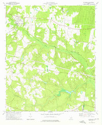
1974 Map of Davisboro
USGS Topo · Published 1976About this map
Davisboro and the surrounding rural landscapes of eastern Georgia are defined by the low-lying wetlands of Williamson Swamp Creek, which cuts a wide, marshy path through the center of the region. The Central of Georgia railroad follows this natural corridor, connecting the small community at Almira with the larger hub at Davisboro. This mid-1970s survey illustrates a landscape deeply rooted in its local congregations, evidenced by a high density of rural houses of worship including Mt Zion Ch, Friendship Ch, New Hope Ch, and Pine Hill Ch.
Find a feature on this map
21 named features on this map. Tap any name to fly to it.
Don’t see what you’re looking for? This feature index may not catch every label — zoom into the map to look around manually.
Map Details
Editions of this 1974 Davisboro Map
This is the sole edition of this map. No revisions or reprints were ever made.
Other maps of this area

1920 · Stapleton
USGS Topo · 1:62,500

1948 · Stapleton
USGS Topo · 1:62,500

1948 · Louisville
USGS Topo · 1:24,000

1950 · Louisville
USGS Topo · 1:24,000

1953 · Athens
USGS Topo · 1:250,000

1957 · Macon
USGS Topo · 1:250,000

1958 · Macon
USGS Topo · 1:250,000

1958 · Athens
USGS Topo · 1:250,000

1959 · Athens
USGS Topo · 1:250,000

1963 · Athens
USGS Topo · 1:250,000