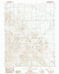
1988 Map of Daylight Pass
USGS Topo · Published 1988About this map
Death Valley National Monument dominates this 1988 survey, where the arid peaks of the Grapevine Mountains and Funeral Mountains converge. The terrain is marked by a legacy of exploration and border-making, notably featuring the Von Schmidt Line and the Nevada California state line. Water sources such as Willow Spring and Daylight Spring represent critical life-sustaining points in this desert environment. Evidence of early infrastructure is visible through the Old RR Grade cutting toward the Amargosa Desert, while numerous Prospects and individual Prospect labels indicate the area's history of mineral exploration. Daylight Pass serves as the primary corridor between the high mountain ridges, providing a view into the transportation patterns that defined this section of Inyo County in the late 20th century.
Find a feature on this map
17 named features on this map. Tap any name to fly to it.
Don’t see what you’re looking for? This feature index may not catch every label — zoom into the map to look around manually.
Map Details
Editions of this 1988 Daylight Pass Map
This is the sole edition of this map. No revisions or reprints were ever made.
Other maps of this area

1908 · Furnace Creek
USGS Topo · 1:250,000

1908 · Ballarat
USGS Topo · 1:250,000

1910 · Furnace Creek
USGS Topo · 1:250,000

1913 · Ballarat
USGS Topo · 1:250,000

1942 · Bullfrog
USGS Topo · 1:125,000

1948 · Death Valley
USGS Topo · 1:250,000

1952 · Chloride Cliff
USGS Topo · 1:50,000

1952 · Stovepipe Wells
USGS Topo · 1:62,500

1954 · Bullfrog
USGS Topo · 1:62,500

1954 · Death Valley
USGS Topo · 1:250,000