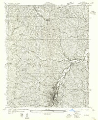
1955 Map of De Soto NE
USGS Topo · Published 1955About this map
The Missouri Pacific railroad corridor anchors this survey, tracing the valley floor near the southern edge of Festus and continuing toward the settlement of De Soto. This topographic record, compiled in part from 1930s Air Corps aerial photography, reveals a landscape defined by its rural education network and narrow winding valleys. Numerous small schoolhouses, including Buckie Sch, Sexton Sch, and New Hope Sch, are distributed throughout the terrain, serving the scattered farmsteads of Jefferson County before the mid-century consolidation of rural districts. The winding path of Joachim Creek dominates the eastern drainage, while infrastructure such as State Highway 21 and a prominent Pipe Line cross the ridges. This map captures the region at a moment when local landmarks like Haverstick Sch and Peter Moore Sch remained as central community nodes for families living in the dissected uplands between the major rail towns.
Find a feature on this map
19 named features on this map. Tap any name to fly to it.
Don’t see what you’re looking for? This feature index may not catch every label — zoom into the map to look around manually.
Map Details
Editions of this 1955 De Soto NE Map
This is the sole edition of this map. No revisions or reprints were ever made.
Other maps of this area

1901 · De Soto
USGS Topo · 1:125,000

1912 · Kimmswick
USGS Topo · 1:62,500

1915 · Crystal City
USGS Topo · 1:62,500

1916 · Kimmswick
USGS Topo · 1:62,500

1930 · De Soto NE
USGS Topo · 1:24,000

1930 · Pacific SE
USGS Topo · 1:24,000

1931 · De Soto SE
USGS Topo · 1:24,000

1937 · Fletcher
USGS Topo · 1:24,000

1937 · Tiff
USGS Topo · 1:24,000

1938 · Cedar Hill
USGS Topo · 1:24,000