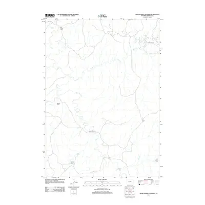
2012 Map of Dead Woman Crossing
USGS Topo · Published 2012About this map
Salt Cr winds through this section of the Powder River Basin in Johnson County, anchoring a landscape defined by seasonal drainages and local landmarks. The settlement of Dead Woman Crossing serves as a focal point in an area where the terrain transitions from the open Frenchy Basin and Frenchy Springs to the elevations of Six Horse Hill. The map detail reveals the importance of water management and topography in this arid region, as evidenced by the numerous named draws and gulches including Sulphur Draw, Shaw Draw, and Metcalf Gulch. Transportation is limited to a sparse network of tracks, notably Sussex Field Rd, which suggests the area's primary use for ranching or resource extraction. The density of drainage labels like Meadow Cr and Crooked Cr provides a fine-grained look at the watershed before it joins the larger Wyoming river systems.
Find a feature on this map
15 named features on this map. Tap any name to fly to it.
Don’t see what you’re looking for? This feature index may not catch every label — zoom into the map to look around manually.
Map Details
Editions of this 2012 Dead Woman Crossing Map
This is the sole edition of this map. No revisions or reprints were ever made.
Other maps of this area

1954 · House Creek
USGS Topo · 1:24,000

1954 · Linch
USGS Topo · 1:24,000

1955 · Arminto
USGS Topo · 1:250,000

1958 · Arminto
USGS Topo · 1:250,000

1959 · Edgerton
USGS Topo · 1:62,500

1961 · Figure 8 Reservoir
USGS Topo · 1:24,000

1961 · Dugout Ranch
USGS Topo · 1:24,000

1961 · Dead Woman Crossing
USGS Topo · 1:24,000
1961 · Sussex
USGS Topo · 1:24,000

1962 · Arminto
USGS Topo · 1:250,000