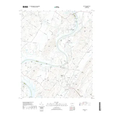
2019 Map of Decatur
USGS Topo · Published 2019About this map
Decatur and the winding course of the Tennessee River anchor this 2019 survey of Meigs County. The landscape is defined by the sharp bends of the river, notably Smith Bend and Forest Grove Bend, which create isolated peninsulas of high ground like Hunter Island. This map reveals a high density of small family and community burial grounds, such as the Old Goodfield Cem and Porter-Ward Cem, offering significant value for genealogical research. The terrain transitions from the alluvial bottomlands of Goodfield Valley to the prominent ridges of No Pone Ridge and Decatur Ridge. Smaller settlements like Breedenton and Calico are connected by a network of historic river crossings, including the site of Breedenton Ferry Rd. The survey also marks key navigational and geologic points along the waterway, from Goodfield Shoals to the northern reaches of Watts Bar Lake.
Find a feature on this map
135 named features on this map. Tap any name to fly to it.
Don’t see what you’re looking for? This feature index may not catch every label — zoom into the map to look around manually.
Map Details
Editions of this 2019 Decatur Map
This is the sole edition of this map. No revisions or reprints were ever made.
Other maps of this area

1886 · Cleveland
USGS Topo · 1:125,000

1887 · Kingston
USGS Topo · 1:125,000

1891 · Kingston
USGS Topo · 1:125,000

1892 · Cleveland
USGS Topo · 1:125,000

1893 · Kingston
USGS Topo · 1:125,000

1895 · Cleveland
USGS Topo · 1:125,000

1901 · Cleveland
USGS Topo · 1:125,000

1935 · Goodfield
USGS Topo · 1:24,000

1935 · Evensville
USGS Topo · 1:24,000

1935 · Decatur
USGS Topo · 1:24,000