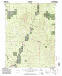
1994 Map of Deckers
USGS Topo · Published 1998About this map
The South Platte River carves a central corridor through the heart of the Pike National Forest, defining the settlement patterns of this Jefferson and Douglas County borderland in the mid-1990s. The community of Deckers serves as a focal point at the confluence of Horse Creek and the river, while smaller clusters like Trumbull and Oxyoke line the valley floor. High-relief features such as Long Scraggy Peak and the Noddle Heads loom over the river's winding path, illustrating the complex geography that constrained development to the narrow canyon bottoms and high ranch lands like Long Scraggy Ranch. Numerous gulches, including Saloon Gulch and Hatch Gulch, drain into the main stem, highlighting the watershed's intricate network. Cultural footprints are visible at the Bridge Crossing and the Swayback Ranch, reflecting a landscape defined by long-established mountain outposts and water-access points.
Find a feature on this map
40 named features on this map. Tap any name to fly to it.
Don’t see what you’re looking for? This feature index may not catch every label — zoom into the map to look around manually.
Map Details
Editions of this 1994 Deckers Map
This is the sole edition of this map. No revisions or reprints were ever made.
Other maps of this area

1893 · Platte Canyon
USGS Topo · 1:125,000

1945 · Platte Canyon
USGS Topo · 1:24,000

1945 · Pine
USGS Topo · 1:24,000

1945 · Kassler
USGS Topo · 1:24,000

1948 · Kassler
USGS Topo · 1:24,000

1948 · Pine
USGS Topo · 1:24,000

1948 · Platte Canyon
USGS Topo · 1:24,000

1953 · Denver
USGS Topo · 1:250,000

1954 · Devils Head
USGS Topo · 1:24,000

1954 · Deckers
USGS Topo · 1:24,000