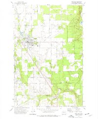
1973 Map of Deer Park
USGS Topo · Published 1977About this map
Deer Park and its surrounding Spokane County landscapes are defined by a network of drainage systems and agricultural infrastructure captured in this early 1970s survey. The town center is densely detailed, featuring the Tri-County Fairgrounds, a Drive-in Theater, and the Arcadia Middle Sch, reflecting a growing community hub for the region. The Burlington Northern railroad runs diagonally through the quadrangle, passing through the settlement of Denison and providing a clear window into the transportation corridors that historically supported local industry and trade.
Find a feature on this map
49 named features on this map. Tap any name to fly to it.
Don’t see what you’re looking for? This feature index may not catch every label — zoom into the map to look around manually.
Map Details
Editions of this 1973 Deer Park Map
This is the sole edition of this map. No revisions or reprints were ever made.
Other maps of this area

1901 · Spokane
USGS Topo · 1:125,000

1927 · Chewelah
USGS Topo · 1:125,000

1930 · Chewelah
USGS Topo · 1:125,000

1936 · Newport
USGS Topo · 1:96,000

1942 · Newport
USGS Topo · 1:125,000

1944 · Clayton
USGS Topo · 1:62,500

1949 · Deer Park
USGS Topo · 1:62,500

1950 · Clayton
USGS Topo · 1:62,500

1951 · Deer Park
USGS Topo · 1:62,500

1955 · Spokane
USGS Topo · 1:250,000