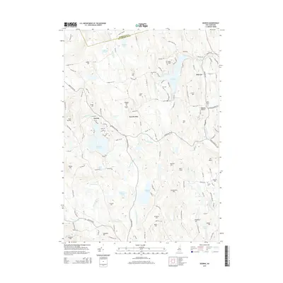
2015 Map of Deering
USGS Topo · Published 2015About this map
Slab City and Clinton Grove anchor the eastern reaches of this Hillsborough County landscape, where the Piscataquog River and its south branch wind through a series of prominent peaks and upland basins. The terrain is defined by numerous named elevations such as Crotched Mtn, Peacock Hill, and Mt Misery, reflecting a rugged New Hampshire geography that shaped early settlement patterns. Several small burial grounds, including South Quaker Cem and Corliss Cem, are preserved across the quadrangle, offering vital points of interest for genealogists and local historians. Large water bodies like the Weare Reservoir and Deering Reservoir dominate the central valleys, while more secluded spots like Dudley Pond and Shattuck Pond dot the higher ground, illustrating the complex drainage of the Merrimack and Hillsborough borderlands.
Find a feature on this map
129 named features on this map. Tap any name to fly to it.
Don’t see what you’re looking for? This feature index may not catch every label — zoom into the map to look around manually.
Map Details
Editions of this 2015 Deering Map
This is the sole edition of this map. No revisions or reprints were ever made.
Other maps of this area

1900 · Peterboro
USGS Topo · 1:62,500

1906 · Milford
USGS Topo · 1:62,500

1926 · Hillsboro
USGS Topo · 1:62,500

1927 · Concord
USGS Topo · 1:62,500

1929 · Hillsboro
USGS Topo · 1:62,500

1943 · Fitchburg
USGS Topo · 1:125,000

1948 · Boston
USGS Topo · 1:250,000

1949 · Portland
USGS Topo · 1:250,000

1949 · Concord
USGS Topo · 1:62,500
1953 · Peterborough
USGS Topo · 1:62,500