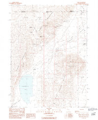
1990 Map of Denio
USGS Topo · Published 1990About this map
Denio sits at the northern edge of the Nevada high desert where the Pueblo Mountains and Pine Forest Range flank a vast arid basin. This 1990 survey captures the isolated borderlands between Humboldt County, Nevada, and Harney County, Oregon, a landscape defined by seasonal water and mining interests. The map records the presence of Continental Lake and Thousand Creek, which contrast with the surrounding Alkali Flat. Local industry and geology are reflected in labels for the Cowden Mine and Hall Mine, as well as several natural water sources such as Baltazor Hot Spring and Erquiaga Spring. The settlement pattern is minimal, centered on Denio Junction and the small townsite of Denio, with a Landing Field providing a vital link to this remote interior region.
Find a feature on this map
28 named features on this map. Tap any name to fly to it.
Don’t see what you’re looking for? This feature index may not catch every label — zoom into the map to look around manually.
Map Details
Editions of this 1990 Denio Map
This is the sole edition of this map. No revisions or reprints were ever made.
Other maps of this area

1886 · Disaster
USGS Topo · 1:250,000

1893 · Disaster
USGS Topo · 1:250,000

1954 · Vya
USGS Topo · 1:250,000

1955 · Adel
USGS Topo · 1:250,000

1957 · Adel
USGS Topo · 1:250,000

1958 · Vya
USGS Topo · 1:250,000

1958 · Adel
USGS Topo · 1:250,000

1962 · Vya
USGS Topo · 1:250,000

1962 · Adel
USGS Topo · 1:250,000

1965 · Railroad Point
USGS Topo · 1:62,500