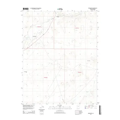
2014 Map of Dennehotso
USGS Topo · Published 2014About this map
Dennehotso serves as the central hub of this high-desert landscape in Apache County, situated near the intersection of Us-160 and several local routes like Bia-118. The geography is defined by significant drainage systems and topographical shifts, most notably the winding course of Laguna Cr as it passes through the depths of Dennehotso Canyon. Further south, the terrain opens into the broad expanse of Greasewood Flat and the wide Chinle Valley, where the ephemeral Tyende Cr and Blackhorse Wash carve through the land. This modern survey illustrates the enduring relationship between the community and these natural landforms, showing how local roads like CO Road C483 navigate the ridges and basins that have shaped Navajo Nation transit and settlement for generations.
Find a feature on this map
16 named features on this map. Tap any name to fly to it.
Don’t see what you’re looking for? This feature index may not catch every label — zoom into the map to look around manually.
Map Details
Editions of this 2014 Dennehotso Map
This is the sole edition of this map. No revisions or reprints were ever made.
Other maps of this area

1892 · Canyon De Chelly
USGS Topo · 1:250,000

1952 · Dinnehotso
USGS Topo · 1:62,500

1952 · Setsiltso Springs 2 NW
USGS Topo · 1:24,000

1952 · Setsiltso Springs 2 SW
USGS Topo · 1:24,000

1952 · Setsiltso Springs 2 SE
USGS Topo · 1:24,000

1952 · Setsiltso Springs 2 NE
USGS Topo · 1:24,000

1954 · Shiprock
USGS Topo · 1:250,000

1958 · Shiprock
USGS Topo · 1:250,000

1959 · Shiprock
USGS Topo · 1:250,000
1968 · Mexican Water
USGS Topo · 1:24,000