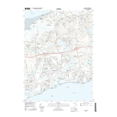
2015 Map of Dennis
USGS Topo · Published 2015About this map
Follins Pond and the Bass River system dominate the central landscape of this Cape Cod mid-section, illustrating a complex network of waterways that defined early settlement. The map documents numerous historical burial sites, including the Ancient Cem and Howes Cem, reflecting the deep genealogical roots of villages like Yarmouth Port and Dennis Port. The terrain transitions from the harbor-facing Mayflower Beach on the northern coast to the barrier beaches and bars of the southern shore, such as Dogfish Bar. Coastal geography is further detailed through features like Scargo Hill and Point of Rocks, which overlook the dense network of interior kettle ponds. The arrangement of Main St and regional connectors like RT-134 shows how the historic village centers of South Yarmouth and West Dennis remained focal points of development into the modern era.
Find a feature on this map
146 named features on this map. Tap any name to fly to it.
Don’t see what you’re looking for? This feature index may not catch every label — zoom into the map to look around manually.
Map Details
Editions of this 2015 Dennis Map
This is the sole edition of this map. No revisions or reprints were ever made.
Other maps of this area

1887 · Wellfleet
USGS Topo · 1:62,500

1887 · Yarmouth
USGS Topo · 1:62,500

1888 · Barnstable
USGS Topo · 1:62,500

1889 · Yarmouth
USGS Topo · 1:62,500

1889 · Wellfleet
USGS Topo · 1:62,500

1893 · Yarmouth
USGS Topo · 1:62,500

1893 · Wellfleet
USGS Topo · 1:62,500

1893 · Barnstable
USGS Topo · 1:62,500

1942 · Cape Cod Bay
USGS Topo · 1:125,000
1942 · Hyannis
USGS Topo · 1:31,680