
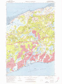
1974 Map of Dennis
USGS Topo · Published 1978About this map
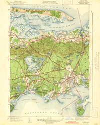
The Bass River serves as a natural dividing line between the growing mid-Cape communities of the mid-1970s, where traditional coastal life meets modern development. This coastal survey showcases the dense network of ponds and inlets that defined the settlement patterns of Yarmouth and Dennis, from the northern shores of Cape Cod Bay to the beaches of Nantucket Sound. The inland landscape is marked by unique landmarks like Hokum Rock and the Observation Tower near Scargo Lake, alongside evidence of regional expansion such as the Cape Cod Coliseum and the Yarmouth Dennis Regional High School. Genealogists will find significant value in the distribution of family and community burial grounds, including the Hall, Paddock, and Quaker cemeteries. The transition of local infrastructure is evident in the Penn Central rail line traversing the townships, linking maritime hubs like Sesuit Harbor with residential centers in South Dennis and South Yarmouth.
Find a feature on this map
110 named features on this map. Tap any name to fly to it.
Don’t see what you’re looking for? This feature index may not catch every label — zoom into the map to look around manually.
Map Details
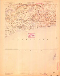
Editions of this 1974 Dennis Map
2 editions found
Other maps of this area

1887 · Wellfleet
USGS Topo · 1:62,500

1887 · Yarmouth
USGS Topo · 1:62,500

1888 · Barnstable
USGS Topo · 1:62,500

1889 · Yarmouth
USGS Topo · 1:62,500

1889 · Wellfleet
USGS Topo · 1:62,500
1893 · Yarmouth
USGS Topo · 1:62,500
1893 · Wellfleet
USGS Topo · 1:62,500
1893 · Barnstable
USGS Topo · 1:62,500

1942 · Cape Cod Bay
USGS Topo · 1:125,000
1942 · Hyannis
USGS Topo · 1:31,680