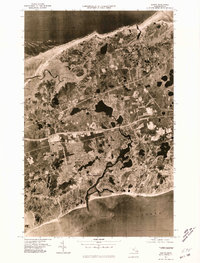
1977 Map of Dennis
USGS Topo · Published 1981About this map
South Yarmouth and Dennis Port anchor the southern coastline of this 1977 orthophotoquad, which captures the mid-Cape landscape through direct aerial imagery. The sheet reveals the intricate network of tidal estuaries and development patterns across the peninsula, from the marshes bordering Cape Cod Bay in the north to the sandy shores of Nantucket Sound. The winding course of the Bass River serves as a prominent natural boundary between Yarmouth and Dennis, while the Swan Pond River drains into the sound further east. Unlike traditional topographic maps, this photographic survey provides a clear view of residential expansion and the specific density of coastal settlements like East Dennis during the late 1970s, offering a literal record of the land surface before decades of further suburban change.
Find a feature on this map
10 named features on this map. Tap any name to fly to it.
Don’t see what you’re looking for? This feature index may not catch every label — zoom into the map to look around manually.
Map Details
Editions of this 1977 Dennis Map
This is the sole edition of this map. No revisions or reprints were ever made.
Other maps of this area

1887 · Wellfleet
USGS Topo · 1:62,500

1887 · Yarmouth
USGS Topo · 1:62,500

1888 · Barnstable
USGS Topo · 1:62,500

1889 · Yarmouth
USGS Topo · 1:62,500

1889 · Wellfleet
USGS Topo · 1:62,500

1893 · Yarmouth
USGS Topo · 1:62,500

1893 · Wellfleet
USGS Topo · 1:62,500

1893 · Barnstable
USGS Topo · 1:62,500

1942 · Cape Cod Bay
USGS Topo · 1:125,000
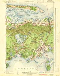
1942 · Hyannis
USGS Topo · 1:31,680